Showing posts with label Alaska. Show all posts

Thursday, August 5, 2010

July 22-24, 2008 -- Top of the World Hwy & Dawson City, Canada

Today we venture out and off the Alaskan Highway to take the Top of the World Highway to Dawson City.  We knew when we started that part of the road would be gravel, and it was recommended that the motorcyclists watch the weather conditions.  Weather report -- "cloudy, warmer, no rain expected".

As advertised, the weather was nice and there were spectacular views and beautiful scenery.  We knew from the information we had received that there would be approximately 26 miles of gravel between the town of Chicken (more later) and the border.  To no surprise, when we arrived at Chicken, the rain also began to fall.  We had already come this far, and thought we knew we should have pavement on the other side of the border when we reached Canada.

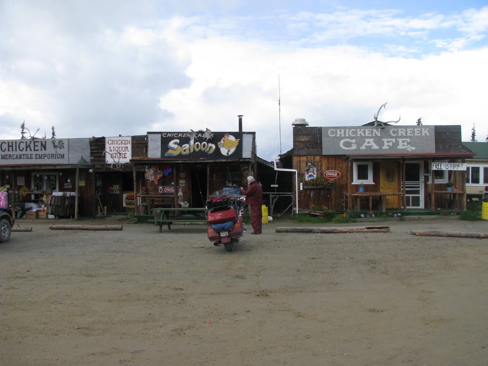
We stopped for lunch in Chicken.  This was an original gold mining area and at one point consideration was given to making it the capital of Alaska.  The original name was to be Ptarmigan (but no one knew how to spell it, so they changed the name to Chicken).  While in Chicken (of all places), we met up with the couple that had the Honda when we began our journey on the ferry.  The main part of town consists of a cafe, bar (now closed because the owners are divorced and he left town), gift shop, and outhouse.

The rain continued as we headed for the Canadian border.  The road separates outside of Chicken (photo above) and the northern route continues on to Eagle.  The other goes to Dawson City.  The information that we had regarding the road on the other side of the border was also incorrect!  The Canadian Highway Department had decided to redo the road between the Canadian border and Dawson City.  So instead of 26 miles of gravel; we had closed to 80.  The best way to describe the ride is going over Trail Ridge in the mud.  However, the drop offs were more like Mt. Evans.  (Bev was glad she had practice on both of these roads before heading to Alaska.)  There were signs along the roadway that said "gravel breaks"; but, because of the length of construction, it was more like "pavement breaks" were which few and far between.  The road was described by many of the bikers that it was more like "peanut butter" mud.  Ed did a great "save" -- we slid along for a while.  Thanks to his dirt biking experience, he was able to keep the motorcycle upright.  He did twist his knee doing ot, so we needed to stay in Dawson City an extra day so he could keep it on ice.  He was complimented by the other cyclists for taking a motorcycle as heavy as the Gold Wing across that type of road.

We crossed the Yukon River on ferry -- so guess you can say we have made the trek from Skagway to Dawson City the same as the sourdoughs (prospectors) did back during the Gold Rush. 


They even have a drink called the Sourtoe Cocktail. Supposedly, it is a toe that they keep preserved and they put it into a shot glass and it has to touch the lips for you to get a certificate. Bev told Ed she would do it as a reward for him keeping them safe over the last leg of the journey.


Bev toured the town between loads of laundry the next day while Ed rested his knee.  We went to Gertie's Dancehall and Salon to see a show and do some gambling.  It was surprising how difficult it was to get used to the short nighttime (see photo of motorcycle above).  Also, while in Dawson we reconnected with Jack London and Robert Service (Canadian poet).  They both had been in Skagway before departing to the gold fields in this area.

Leaving Dawson City, the road to Whitehorse was mostly construction, and it rained most of the day while we were in Dawson; so we were extra glad that we had waited out the time before heading south.  One gal said they were still waiting for summer -- the last time they had seen the sun was Memorial Day.  Another guy along the way had told Ed that summer was last month, and they were now having fall weather.  Other than the weather not being as expected, the scenery was beautiful.  We really only had one cold day on the road (which was today), and the rain hadn't been difficult to drive through unless they had construction on the road.  We stayed in Whitehorse.

July 21, 2008 -- Fairbanks and then back south

From Denali we drove through Fairbanks for lunch and a quick visit.  Our lunch was at the Historic Chena Pump House.  http://www.pumphouse.com/


While trying to get a picture of a fighter plane landing at Eielson Air Force Base, but instead we had a moose appear on the opposite side of the road.
North Pole, Alaska is just south of Fairbanks, so we stopped to see if we could get a good word in with Santa.


On the way to Delta Junction we passed by the Alaskan pipeline.
At Delta Junction we got back on the Alaskan Highway.  Although Fairbanks has a mileage marker in the city, this is the official end of the highway.  They consider the start of the highway to be a Dawson Creek, Canada.  We drove the Alaskan Highway in reverse.  A hawk flew up from the side of the road and we barely missed it.  We traveled on to Tok where we spent the night.  The cruise lines for Alaska now have their own hotel chains scattered throughout the state and Canada.  This allows the cruise lines to offer trips inland by bus that previously could not be offered.  There was a group staying at our hotel in Tok.  The conversation was about the potential workers' strike at Denali Park.  Luckily we had already been there.  Guess they have surprises like these everywhere one travels.

July 19-20, 2008 -- Anchorage and Denali

We drove to Anchorage from Soldotna that night.  We arrived in time for happy hour, but after visiting with the bears all day, people weren't of much interest to us.

The next morning we saw some of the highlights of the city (train station, Eisenhower memorial, and a street fair for some), and then headed towards Denali. We stopped in Wasilla to see the Iditarod Dog Sledding Museum; and, got to take a ride on a dog sled. Although there wasn't any snow, they set up a trail for the dogs to give you "a feel" of being on the run. Outside of Denali, we stopped at the town of Talkeetna. This is where the climbers depart for their climb on Mt. McKinley. As always, the drive everywhere was beautiful.

Talkeetna Airstrip
 Arrival at Denali National Park -- we stayed in cabins with the bathrooms in a separate building. 


The following morning we took the bus into the interior of the park (12 hours; 90 miles).  We got to see what our guide called a Denali Royal Flush -- caribou, grizzly bear, Dall sheep (mainly from a distance), gray wolf (ran across the road), and a bull moose (grazing in the willows by the road).  Ed was worried that we wouldn't see a moose, and it was within the last 1/2 hour of the trip that we saw it.

July 18, 2008 -- Glaciers and 'DA' Bears

Today was a highlight of our trip.  We wanted to make certain that we would get to see some Alaskan bears!!  When we booked our bear watching trip, they asked if we would need fishing licenses.  So, we also got to do some fishing for Alaskan salmon on the same trip.  First, eight of us were loaded into a small seaplane and transported across to the western shore of Cook Inlet.  Here there is a nature refuge.


We had told our guide that the emphasis was on bear watching.  So after we landed in a lake at the Refuge, we boarded fishing boats from the plane, and went to the inlet where the creek connects with the lake.  This is where the salmon return each year to spawn, and of course, where there is salmon, there are bears!!  There were five of us in the boat, us, our guide, and fellow motorcycle riders who were staying in their trailer in Alaska for the summer.  (Their trailer is used as a motorcycle hauler/residence).
Our guide got our fishing boat situated so we would definitely see the bears -- there were about 7 fishing boats jockeying for position on the stream.  Even tho' we didn't have the best fishing spot, Ed caught 3 (daily limit for out-of-state licenses) and Bev caught one.  Our new friends also gave us theirs to take home.  There had been other catches for all of us, but Alaska law states that the fish needs to be caught with the hook in the mouth; so if the hook is attached anywhere else, then had to put the fish back into the water.
Best part of the trip tho' was the presence of the mother bear and her 3 cubs.

They came down to the lake twice throughout the day.  The first time was to just get a drink of water. 
 Then the next time they came down to eat.  When they were done eating, the guide said they would be coming our way.  We thought he meant on the land (which was about 50 feet away).  Instead, mother bear came into the water that was half way between us and shore.  WOW!!  We did get some good pictures of this. 


Mom took time to take a bath and then show the youngsters how to wash their ears


Much to our surprise because this wasn't advertised, after we left the lake where we were fishing, the pilot took us for a close up view of the Mt. Redoubt glacier.  They don't advertise this portion of the trip because they never know when the weather is going to cooperate.  Here is the view looking down into the glacier.  Mt. Redoubt had been dormant for a long time, so we were quite surprised  when we read in the 2009 paper that the volcano had beecome active again.

After the trip was over, we had to arrange to get back to Soldotna and arrange to ship the fish home.  We joked on the way back to the plane about me carrying the fish on the back of the motorcycle while we drove the 30 miles into town.  The other couple had their truck, so offered to drop the fish off at the processor.  The fish weighed out at 18 pounds; and they were in Fort Collins when we arrived home.

July 15-17, 2008 -- Seward

After leaving Palmer we originally had planned to pass thru Anchorage (knowing we would be there on the return trip), but had to stop and purchase a headlight bulb.  Gravel can be troublesome!  As a surprise we ran into one of the motorcycle couples that had been on the ferry when we left the States.

The ride from Anchorage to Seward follows the Seward Highway along the Turnagain waterway -- which is actually part of the ocean.  Unfortunately, the tide was out, so we weren't able to see any beluga whales.  The area is surrounded with glaciers.

We stayed at an Inn in Seward.  There was a shared kitchen and TV room and the bedrooms and baths are private.  The owner took care of the Inn and his wife worked construction during the day.  They had previously owned a boat and had lived on it for several years.


 We took the evening dinner fjord trip. That was wonderful. We were able to see several types of sea life. We saw a humpback whale with her calf, a school of orca whales, sea lions, puffins, sea otter, and, on land, a black bear. We were served a salmon dinner, and although rainy, we saw some beautiful seaside country.

They also took us to a glacier and it seemed very strange floating in the middle of large ice chucks. 


From Seward we traveled to Soldotna.  Leaving Seward we stopped at the Exit Glacier. 
We have adapted to driving in the rain.  Everyone has told us that it was a very strange summer for Alaskan weather with all the moisture.  While in Soldotna, we came across a 'chain saw craving' contest.  You wouldn't believe what they can make with a chain saw!!

<><><><><><><><><><><><><><><><><><>
<>
<><><><><><><><><><><><><><><><><><>
This is now in our livingroom!

July 13-15, 2008 -- On the Road Again

We took off from Haines via motorcycle on the Haines Highway.  Felt good to be riding again.  Saw a black bear cub and a large brown bear on the road from Haines to Haines Jct.  Road was good and the scenery was beyond description.  It was a little chilly, but no rain.  We left Alaska and entered the Canadian Yukon Territory.  We would connect with the Alcan Highway at Haines Junction.  Throughout our journey, there will be only one stretch of the Alcan that we will not drive on.                     History of the Alcan -- The Alcan Highway was originally built as a military route to transport troups, supplies, and aircraft from the lower 48 to Alaska.  Russia (as Sarah Palin says) is right next to the Alaskan border.  Throughout the trip, there were many areas that had been impacted by World War II.
The Alcan Highway is said to be paved, but between construction and frost heaves, that is debatable.  There was construction from Haines Jct to Tok, and I believe there was more gravel on the road there than what they had described for the Top of the World Hwy to Dawson City.  We talked to a rider from Silverton, CO and he said that he wasn't going to return the way we came, was going to take the "World" road back.  At least they admit there are areas on the "World" hwy that have gravel sections.


Having talked with several motorcyclists along the way, we learned that the orange flags along side the road would become our friends.  The flags marked the areas where there would be bumps.  The worse ones had either dip or slower mileage signs or both.  We also learned that the dark patches in the road meant that that section used to have an orange flag, then there was an attempt to patch, but then with the heavy trucks, they became pot holes.  As Ed says, "some of the potholes are deep enough for a gopher to live in."  Ed was very conscience of the road, and we only had a couple of teeth-rattling experiences.


We stayed in 1/2 of a modular at one stop and in the bunkhouse at the Sheep Mountain Resort on our way to Palmer.  The resort is also used in the wintertime for cross country skiing and dog sleds.  It was hard to believe that we were over timberline at 3,700 feet. 

The road crossed the 141st meridian which was the original boundary between Alaska and Canada when an 1825 treaty was signed between Russia and England. This is the boundary that the US understood to be when the purchase was made from Russia. However, when gold was discovered in 1896, a dispute arose between the US and Canada regarding the location of the boundary. In an international tribunal in 1903, the US was favored with the original division.

North of Anchorage (Palmer area) is the Musk Ox Ranch (also see photo above).  These animals are raised for domestication.  They are what would be referred to as a "Pre-Historic Goat."  They had been nearly extinct because of their valuable wool, and now they raising them for both domestication and some released into the wild.


Wednesday, August 4, 2010

July 11-12, 2008 -- Haines & Skagway

From Juneau to Haines, the ferry travels through the Lynn Canal.  Hard to believe it is the ocean when you are surrounded by mountains.  We got to see several lighthouses.  We had a moose and calf greet us shortly after we left the ferry dock in Haines.  That was a pleasant surprise!
We stayed in a hotel that was renovated from the officer's quarters of the original Fort Seward.  Fort Seward was the first army post in Alaska.  There are still several buildings that surround the parade grounds.  http://www.bellsalaska.com/haines.html


We took the Fast Ferry (no motorcycle) to Skagway.  The ride was nice and the visit to Skagway was interesting.  Gave us more of a perspective of the hardships that the gold seekers had to go through when they came for the gold rush.   http://www.skagway.com/
 

We have made our first 1000 driving miles.  With the ferry, it has taken us almost two weeks to accomplish.

July 9-10, 2008 -- Juneau

We left Sitka on a large catamaran through the ferry system to Juneau.  Took about 1/2 the time of the regular ferry and quite exquisite inside.  They didn't have any lodging, but the seating was quite comfortable.  Of course, there was beautiful scenery along the way.


Juneau was an experience within itself.  From staying in the oldest still-operating hotel to having five luxury cruise ships in port.  It was quite a range of experience.  We opted to have a room with a shared bath, but sharing it with the local residents caused us to upgrade to a private room the next night.  The hotel was quite quaint, located in the central historic portion of downtown Juneau.  There was a bar downstairs, but we were lucky that the noise didn't travel upward.  Parking in historic Juneau is "everyone fends for themselves".  One of the residents in the hotel drove a Harley, so he waited until a parking space became available and then we parked with 3 Harleys for the night.  Otherwise, Ed could park the motorcycle on the hill behind the hotel -- it would only take 83 stairs one way to access it  We were able to leave it in covered parking the next night.  There is a lot of history in this area.  We had a beer and hamburger at the Red Dog Saloon.  http://www.reddogsaloon.com/ 


Raining as usual -- we got up early the second day and drove out to the Mendenhal Glacier.  One doesn't realize how large the glaciers are until you get up close.  We were early enough that the first tour bus hadn't arrived.  Quite serene, and you could hear the sound of the waterfall.  There are a total of 47 driving miles in the Juneau area.  We managed to drive 70 with some backtracking from the glacier.  The town of Douglas is across the bridge, so we were also able to see Juneau from the other side of the bay.  That evening we had dinner at the Hangar Bar -- here we sat at the bar and watched the sea planes land.
Can you see the small plane!


 We actually had a reasonable boarding time for the ferry, so we took the Alaskan Brewing Co. tour. Quite interesting! They had expanded on a brew that had been brought over from Czech back during the gold rush days. The Czech had brought his own ingredients and the beer was stored in caves. Today, this is the fastest growing micro-brewery. They started delivery in Colorado recently -- might want to try the Amber, Summer Ale, or Smoked Porter if you get the chance. Because of their volume in sales, they are no longer considered a micro-brewery. http://www.alaskanbeer.com/


July 7-8, 2008 -- Sitka

We had to be in the line at 4:00 AM to catch the ferry to Sitka.  It was another night on the ferry, but we slept inside on this trip.  (We donated our tent to the last ferry's crew.)  Gordon (our 67 year old motorcyclist) joined us on this leg of the trip.  While we were waiting at the terminal, the Ketchikan Harley Davidson owner came over to talk with Ed and Gordon about riding boots.  Then on the ferry there were 5 more riders -- a couple from Seattle and 3 gals.  The Seattle wife was introduced as the couple's GPS, which is what I am by telling Ed which roads to take.  One of the gals retired from BMW Motorcycles and had her motorcycle shipped to Seattle from Boston so she could take this trip.  We had more fun with non-riders stopping and talking to us about where we had come from and the motorcycle rides.


We arrived in Sitka at 5:15 AM (sleeping a few hours on the floor of the lounge on the ferry).  The scenery was beautiful through this area.  One of the advantages of going on the ferry is that you get to travel through the Wrangell Narrows.  It is a waterway where it appears almost as a river.  It is about 21 miles long, and there are channel markers along the way.  Someone from the captain's crew needs to stand at the front of the boat and give hand signals to the captain.  We did it in the daylight.  Sounds quite interesting at night, however, because the channel markers flash green and red, it gives almost an optical illusion as you are looking down the channel.  Another advantage of the ferry is we
got to stop at Wrangell, Petersburg and Kake (which are not normal stops for the cruise line).  These towns are part of the fishing industry.  We were able to see a couple of more whales and some otters -- but, of course, I wasn't ready with the camera.


A little history of Sitka -- it used to be the capital of Russia-America prior to the United States purchasing it.  There wasn't much open when we got off the ferry, so we had breakfast and then did some touring in the rain.  St Michael's Cathedral (Russian Orthodox) is beautiful.  Across the street is the first Lutheran Church on the west coast of North America (established by the Finns).  We climbed Castle Hill where on Oct 18, 1867, it was the site of the transfer of Alaska to the United States as a territory.  The view was beautiful from what we could see.  It is strange seeing a fishing wharf on the ocean, with a volcanic mountain in the background covered with snow.  It took Ed to see the New Archangel Dancers -- although none of the performers are Russian, they have continued the tradition of learning Russian dances and performing for many Sitka visitors.  (Visitors included passengers from of the cruise ships that was in port that day.)  We also visited the historic museum and learned so much more about Alaska's involvement in World War II. 

After not being able to check into the hotel right away, and having to walk around in our riding boots, Ed had to fit our boots with cushioned insoles.  We then took a motorcycle ride around the island and saw the Coast Guard base and the University of Alaska-Sitka.  We were also able to visit the Sitka National Historic Park, which houses the history of the Tlingit Indians and their takeover by the Russians.  The park was full of about 25 totem poles.

July 6, 2008 -- Ketchikan


We arrived in Ketchikan at 7:00 AM after two nights on the water.  Had to breakdown the air mattresses and repack the bags, etc. and then had to repack the motoryclc to get off the ferry.  We were the lucky ones because those that were continuing on had to change ferries here because the ferry we were on had to go into maintenance.  That meant they had to repack and unpack unexpectantly.  The folks on the motorcycles weren't too pleased because they had packed to bring everything on board once.

Ketchikan is quite a neat town.  We walked through the downtown area and visited the Totem Heritage Center.  There was a cruise ship in town, but not a lot of folks around the stores.  We stayed in one of the older hotels in downtown Ketchikan (had to share a toilet and bathtub).  The hotel overlooked main street and the waterfront.  There was snow on the peaks on the hills across the bay.  We could watch seaplanes take off and land from our room.

The older section of town along the creek was where the original settlers had resided.  We visited one of the original brothals.  The railcar took us a hotel at the top, and then we walked back down seeing more totems and other historic builidngs.